Wikipedia ~ Netherlands Antilles
Map: www.worldatlas.com
The Netherlands Antilles (Dutch: Nederlandse Antillen [ˈneːdərˌlɑntsə ɑnˈtɪlə(n)] , Papiamentu: Antia Hulandes), also referred to informally as the Dutch Antilles, was an autonomous Caribbean country within the Kingdom of the Netherlands. Although the country has now been dissolved, all of its constituent islands remain part of the kingdom under a different legal status and the term is still used to refer to these Dutch Caribbean islands.
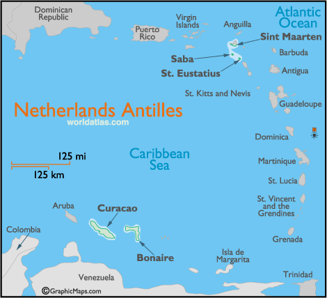
The Netherlands Antilles consisted of two distinct island groups. First, the “windward” or “ABC Islands” — Aruba, Bonaire, and Curaçao — are located in the southern Caribbean Sea, just off the Venezuelan coast. Second, the “leeward” or “SSS islands” — Sint Maarten, Saba, and Sint Eustatius — are part of the Lesser Antilles; they are approximately 800–900 kilometers (500–560 miles) northeast of the ABC Islands. The Dutch colonized the various islands in the 17th century and united them as the Netherlands Antilles in 1954.
The Netherlands Antilles was dissolved on 10 October 2010. Curaçao and Sint Maarten became distinct constituent countries alongside Aruba which had become a distinct constituent country in 1986; whereas Bonaire, Sint Eustatius, and Saba (the “BES Islands”) became special municipalities within the Netherlands proper.
Read more: http://en.wikipedia.org/wiki/Netherlands_Antilles