Wikipedia ~ Suriname
Map: zainuddin.net
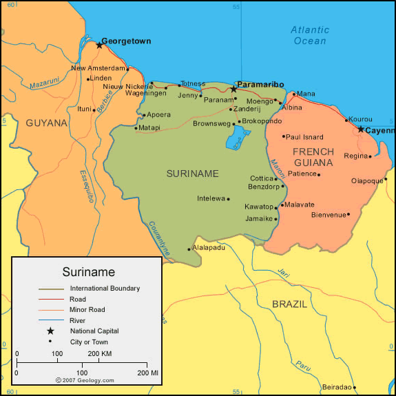
Suriname (/ˈsʊrɨnæm/, /ˈsʊrɨnɑːm/ or /ˈsʊrɨnəm/, also spelled Surinam), officially known as the Republic of Suriname (Dutch: Republiek Suriname, Dutch pronunciation: [ˌreːpyˈblik ˌsyːriˈnaːmə]), is a country on the northeastern Atlantic coast of South America. It is bordered by French Guiana to the east, Guyana to the west and Brazil to the south.
Suriname was colonized by the English and the Dutch in the 17th century. In 1667 it was captured by the Dutch, who governed Suriname as Dutch Guiana until 1954. At that time it was designated as one of the constituent countries of the Kingdom of the Netherlands, next to the Netherlands and the Netherlands Antilles (dissolved in 2010). On 25 November 1975, the country of Suriname left the Kingdom of the Netherlands to become independent. A member of CARICOM, it is considered to be a culturally Caribbean country and has extensive trade and cultural exchange with the Caribbean nations.
At just under 165,000 km2 (64,000 sq mi), Suriname is the smallest sovereign state in South America. (French Guiana, while less extensive and populous, is an overseas department of France.) Suriname has a population of approximately 566,000, most of whom live on the country’s north coast, where the capital Paramaribo is located. Suriname is a mostly Dutch-speaking country; Sranang, an English-based creole language, is a widely used lingua franca. It is the only independent entity in the Americas where Dutch is spoken by a majority of the population.
Read more: http://en.wikipedia.org/wiki/Suriname